
Fire‑related tree cover loss and the Hansen–Fra discrepancy in the Amazon basin (2015–2023): implications for SDG forest monitoring
Article Sidebar
Main Article Content
Abstract
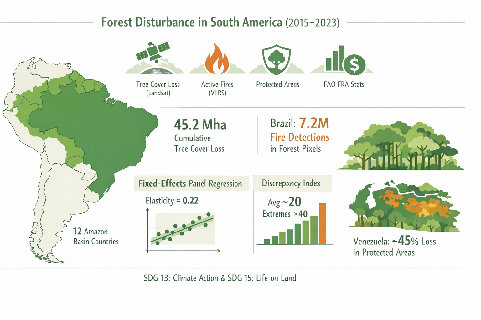
Forest disturbance related to fires has increased in many regions; however, the extent to which annual fire activity explains the recent loss of tree cover in the Amazon basin and in South American forest systems in general remains insufficiently quantified. This study constructs a harmonized country-year panel for twelve South American countries for the period 2015–2023. The panel includes twelve countries influenced by the Amazon basin (Argentina, Bolivia, Brazil, Chile, Colombia, Ecuador, Guyana, Paraguay, Peru, Suriname, Uruguay, and Venezuela) to capture regional forest dynamics in adjacent biomes. The dataset integrates tree cover loss derived from Landsat, active fire detections from VIIRS, protected area boundaries, interpolated FAO forest area statistics, and macroeconomic indicators. During the study period, the region experienced approximately 45.2 million hectares of cumulative tree cover loss, with Brazil registering the largest share, accounting for over 7.2 million VIIRS fire detections in forest pixels. Forest loss is quantified using a 30% forest cover threshold and analyzed using a fixed-effects panel regression to assess the relationship between fire activity, economic structure, and annual forest disturbance. Year-to-year variations in VIIRS fire detections are closely related to forest cover loss, with an estimated elasticity of loss with respect to fire of approximately 0.22 percent across model variants and forest cover thresholds. A discrepancy index comparing Hansen's gross forest cover loss with the net change in forest area from the FAO Forest Resources Assessment (FRA) indicates that a substantial portion of canopy disturbance is not reflected in national forest statistics. Average discrepancy indices approach 20 in some countries and exceed 40 in extreme annual cases, suggesting that degradation and temporary disturbance are underrepresented in land-use-based reports. Loss within protected areas is also significant, particularly in Venezuela, where approximately 45% of total forest cover loss occurs within protected boundaries. These findings highlight the growing role of fire as a proximate driver of forest disturbance and underscore the need to integrate satellite-based disturbance monitoring with national inventories and socioeconomic data to improve assessments of forest dynamics and progress toward Sustainable Development Goals 13 and 15.
Downloads
Article Details

This work is licensed under a Creative Commons Attribution-NonCommercial-NoDerivatives 4.0 International License.
![]()
You are free to:
- Share — copy and redistribute the material in any medium or format
- The licensor cannot revoke these freedoms as long as you follow the license terms.
Under the following terms:
- Attribution — You must give appropriate credit , provide a link to the license, and indicate if changes were made . You may do so in any reasonable manner, but not in any way that suggests the licensor endorses you or your use.
- NonCommercial — You may not use the material for commercial purposes .
- NoDerivatives — If you remix, transform, or build upon the material, you may not distribute the modified material.
- No additional restrictions — You may not apply legal terms or technological measures that legally restrict others from doing anything the license permits.